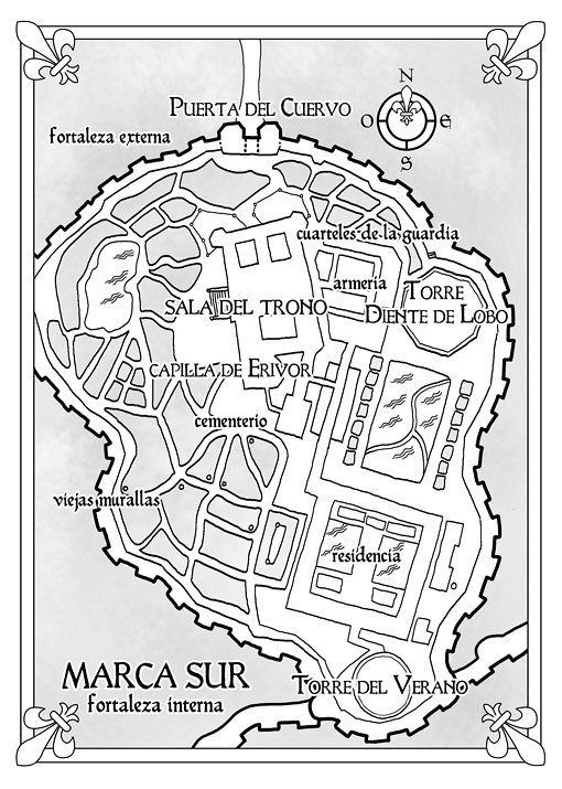
These are the Shadowmarch map illustrations I created for the Spanish edition of Shadowmarch (La frontera de las sombras), the fantasy novel by Tad Williams, published in Spain by Alamut Ediciones. There are four maps in total: two of the world where the story takes place and two of the castle of Southmarch, the heart of the novel.
Shadowmarch map
The four Shadowmarch maps
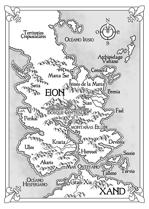
Eion and Xand
The first map shows the continent of Eion, from the Twilight lands in the far north to the lands across the sea in the south, where the great empire of Xand begins. It includes kingdoms and cities such as Southmarch, Connord, Brenland, Fael, Sian, Devonis, Kracia, Perikal and Hierosol, the great central forest and the mountain ranges that divide the continent.
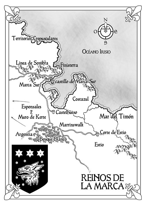
The March Kingdoms
The second map zooms in on the March Kingdoms and the border with the Shadowline, the mysterious frontier that separates the human lands from the realm of the Twilight People. It also features a coat of arms with a wolf and three stars.
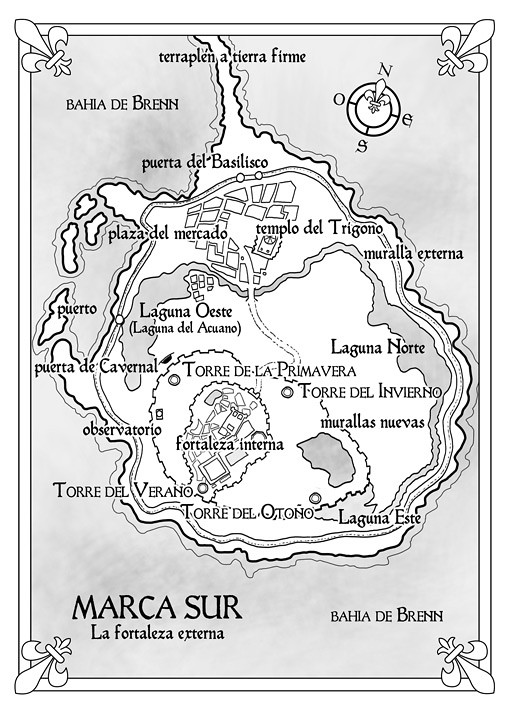
Southmarch: the outer and inner keep
The last two maps are plans of the castle of Southmarch, built on an island in Brenn’s Bay. One shows the outer keep, with its walls, gates, temples, towers, lagoons and market square; the other shows the inner keep, with the throne hall, the chapel, the barracks, the armory and the royal residence. They are the kind of maps that help the reader follow every scene that happens inside the castle walls.
Style of the maps
All four maps are drawn in black ink with grey shading, framed with fleur-de-lis corners and a compass rose, so they print cleanly on the pages of the book and share a single visual language. The idea was that the reader could move from the scale of a whole continent to the corridors of a castle and still feel they were looking at documents from the same world.
Why the book needed four maps
The story of Shadowmarch moves between very different scales: the corridors and towers of the castle, the misty lands beyond the Shadowline and distant places such as Hierosol and Xand. A single map could not show all of that clearly. Splitting the cartography into a world map, a regional map and two plans of the castle lets readers check the big picture and the small details whenever they need to, without getting lost.
About Shadowmarch and Tad Williams
Tad Williams is an American fantasy author, best known for the series Memory, Sorrow and Thorn. Shadowmarch is the first book of a four-volume series set in the castle of Southmarch, on the edge of the Shadowline. When the young heir of the royal family is murdered and the king is held captive far away, the twins Barrick and Briony must protect the kingdom while the ancient people beyond the Shadowline begin to stir.
With so many kingdoms, factions and locations, a good Shadowmarch map is almost essential to follow the story. If you are curious about the novel, Alamut published a PDF preview of the Spanish edition.
Shadowmarch map: frequently asked questions
Are these the maps of the Spanish edition of Shadowmarch?
Yes. I illustrated them for Alamut Ediciones, the Spanish publisher of the novel.
Can you illustrate a map for my own fantasy novel?
Of course. I work with publishers and self-published authors. Take a look at my The Witcher map or my Tigana map, visit my map illustration page, or get in touch to tell me about your project.